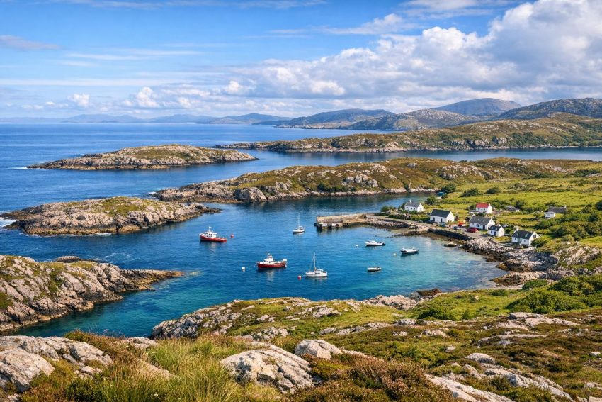
Scalpay is a small island off the east coast of Harris in the Outer Hebrides. Its shoreline is shaped by open water, sheltered channels and narrow inlets cut into hard rock. Although the island covers only about 2.5 square miles, its coast contains exposed headlands, low shelves, small sandy coves, sea lochs, tidal skerries and protected moorings close to the main settlement.
The island lies in the Harris Sound, with its eastern and southern waters opening into the Minch. To the west, a narrow channel separates Scalpay from Harris. The Scalpay Bridge has crossed this channel since 1997, replacing the ferry as the usual means of access. Road travel became far easier after the bridge opened, but the island retained its close connection with fishing, small boats and coastal transport.
Scalpay’s bays rarely match the broad beaches associated with western Harris. Here, shelter often comes from rock rather than sand. Headlands block part of the swell, offshore reefs break incoming waves, and crooked entrances reduce the amount of open water entering an inlet. The result is a coast where a short distance can separate a calm anchorage from rough, tide-driven water.
The shape and setting of Scalpay’s coast
Scalpay has an irregular outline, with points and bays interrupting almost every side of the island. Much of the underlying rock is Lewisian gneiss, an ancient metamorphic rock found across large parts of the Outer Hebrides. It is hard, heavily folded and crossed by fractures. Erosion has acted more readily along weaker lines, helping to form narrow channels and indented bays.
Ice also played a major part in shaping the island. During past glacial periods, moving ice widened hollows, scoured exposed rock and altered earlier drainage lines. When sea levels later rose, lower depressions filled with salt water. Some coastal inlets therefore resemble flooded rock basins rather than river estuaries. Scalpay has small burns, but no large river has deposited a broad delta or carved a major valley through the island.
The higher ground is mostly open moorland, rough grazing and exposed rock. Peat occupies wetter hollows, while grass and heath cover better-drained slopes. Trees are scarce, so wind reaches most parts of the coast without much obstruction. Even a bay protected from swell can feel exposed on land when a strong wind crosses the island.
The west coast receives some shelter from Harris and nearby islands. The channels here are narrow and visually enclosed, though tidal flow can remain fast. The east coast faces the Minch more directly. It receives longer waves during easterly and south-easterly weather, especially when wind has travelled over a broad stretch of water before reaching the island.
No bay stays protected in every wind direction. A western inlet may remain calm during an easterly but become awkward when strong wind arrives from Harris. An anchorage on the opposite coast may behave in reverse. Local boat users assess both the present conditions and the forecast because shelter at the time of arrival may not last through a change in wind.
Low rocky platforms occur around much of the shore. Some disappear beneath high water, leaving isolated rocks and skerries visible offshore. Other sections rise into steeper slopes and short cliffs. The boundary between land and sea changes through each tidal cycle, which makes the coastline appear broader and more broken at low water than it does near high tide.
Rock, water and coastal erosion
Lewisian gneiss resists erosion better than softer sedimentary rocks, but resistance does not mean permanence. Salt water enters cracks, repeated wetting and drying weaken exposed surfaces, and winter cold can enlarge fractures. Waves then remove loosened material. On sheltered shores this process is slow and may leave rounded blocks in place for years. Exposed points lose smaller fragments more readily during storms.
The orientation of cracks in the rock has influenced the direction of several inlets. Long, narrow bays often follow structural weaknesses rather than taking a random course. Smaller coves may form where two sets of fractures meet. This relationship between geology and shoreline shape is easy to see from higher ground, where straight rock edges contrast with the irregular line of the water.
Coastal change on Scalpay usually occurs in small increments rather than through the rapid retreat associated with soft cliffs. Storms can move boulders, remove shingle and strip vegetation from exposed ground. Sand may shift from one end of a cove to another and then return during calmer conditions. The hard rock framework changes far more slowly.
An Acarsaid and Scalpay’s principal harbour
An Acarsaid is the island’s main harbour area and one of its best-known coastal features. The Gaelic name refers to a harbour or anchorage, which says a good deal about the site’s long-standing use. It occupies an indented section of coast where surrounding land, islands and reefs reduce exposure to open water.
An Acarsaid is not a large commercial port. It is a working island harbour suited to fishing vessels, service boats and smaller leisure boats capable of operating in Hebridean waters. Its practical value comes from its sheltered position, usable approaches and proximity to houses, roads and other local services.
The harbour includes quays, landing areas and moorings associated with fishing and boat work. Facilities have changed with the needs of the island, but the basic reason for the harbour’s location has remained the same: the natural shape of the inlet provides better protection than much of the surrounding coast.
Before the bridge opened, coastal access had greater importance in everyday transport. Boats carried passengers, supplies, mail, fuel and fishing gear. A usable landing place was part of the island’s transport network rather than a separate industrial site. Weather could interrupt travel, and harbour activity often followed the practical timetable imposed by tide and wind.
The road bridge changed that pattern. Goods and passengers could move between Scalpay and Harris without waiting for a ferry crossing. Even so, a bridge cannot perform the work of a harbour. Fishing boats still need moorings, quays and places where crews can load gear or land catches. Workboats also require access for maintenance and crew changes.
Why An Acarsaid offers shelter
Natural harbour protection depends on several connected features. The entrance should prevent the full force of open-water swell from reaching the inner anchorage. Surrounding land should reduce exposure to common wind directions, and the water should have enough depth for the vessels using it. An Acarsaid benefits from an entrance that does not present a broad, direct opening to the Minch.
Reefs and skerries can add protection by breaking waves before they reach the inner water. They also create hazards. A rock that reduces swell in one state of the tide may sit just beneath the surface at another. Safe approach therefore depends on charts, buoyage where provided and local knowledge.
The term sheltered harbour should not be read as a promise of calm conditions. Strong wind can funnel along an inlet, and reflected waves may make berthing awkward. Tidal flow can affect the harbour entrance, while low water may reduce depth near the shore. A skipper must assess the harbour as it is, not as it looked during a calm visit in July.
Harbour activity and settlement
Homes and working buildings developed near An Acarsaid because the harbour gave residents practical access to the sea. This pattern appears across the Hebrides: settlement often follows usable landing places rather than the most visually attractive stretches of coast. A rocky cove with dependable shelter could matter more than a wide beach exposed to swell.
Fishing shaped daily routines around the harbour. Departure times depended on weather, tidal state and the location of the grounds being worked. Gear needed storage, boats needed repair, and catches had to move ashore. These activities connected the water directly with roads and homes nearby.
The harbour also acted as a meeting point. Crews exchanged weather observations, information about catches and details of hazards. Formal forecasts and electronic navigation now provide far more data, but practical observation still matters. Water colour, wave patterns and wind over nearby ridges can reveal changes that a general forecast does not describe at harbour scale.
Scalpay’s bays and sheltered inlets
Most bays on Scalpay are small. Some are narrow coves between rock points; others run inland as short sea lochs. A few appear almost enclosed at high water, with their connection to the sea reduced to a slender opening. Their size does not determine their usefulness. A modest inlet with good holding ground and protection may serve a boat better than a broad bay open to wind.
The northern and western shores include inlets influenced by the sheltered waters between Scalpay and Harris. Surface conditions may look calm here even when the Minch is rough. Yet narrow channels can carry strong tidal streams, particularly where water must pass through a constricted gap.
Eastern bays receive more direct exposure. Wave energy can enter from the Minch, and reflected waves may create confused water near rocky sides. During settled weather these coves can still be approachable, but conditions change faster when an easterly wind strengthens.
Southern shores combine open exposure with a broken line of points, skerries and passages. Offshore rocks can produce breakers at some tidal stages. In poor visibility, the apparent gap between two rocks may not match a safe navigable passage. Detailed marine charts remain necessary even for boat users familiar with the general outline of the island.
What counts as a bay on Scalpay?
Local coastal names do not always match modern visitor expectations. A place called a bay may have little sand and no easy landing. Its shore may consist of boulders, bedrock, mud or seaweed-covered slabs. The name often refers to the shape and use of the water rather than its value for bathing.
At high tide, a cove may appear full and harbour-like. Six hours later, much of its floor can lie exposed. Narrow streams wind through mud, rock pools occupy shallow basins, and weed-covered shelves connect to offshore rocks. The same cove can therefore look like two quite different places within a single day.
Small pockets of shingle often form above the normal high-water line. Storm waves throw coarse material farther inland, creating ridges that may remain dry during ordinary tides. Fine sand tends to collect in more protected corners. Repeated wave action sorts the material by size, though a winter storm can rearrange it in a few hours.
Gaelic coastal place-names
Many place-names on Scalpay come from Gaelic and record how residents viewed or used the coast. Terms may refer to an anchorage, headland, narrow channel, rock, island, beach or colour. Such names often describe a physical feature with notable accuracy.
Place-names also preserve working knowledge. A reference to a skerry may warn of rock near a route, while a harbour name may mark a cove used before modern quays existed. Names associated with colour can refer to rock, vegetation or the appearance of water. Their meanings should be treated with care, since spelling and interpretation may vary between maps and oral usage.
Visitors using older maps may find more than one form of the same name. Anglicised spellings, Gaelic spellings and local pronunciation do not always align neatly. This is normal in an island community where oral naming traditions developed long before standardised mapping.
Beaches, rocky shores and tidal ground
Scalpay does not have the long machair-backed beaches found on western Harris, North Uist or South Uist. Its beaches are generally short, narrow and enclosed by rock. Some contain pale sand, while others are mixtures of gravel, broken shell and rounded stones.
Sediment settles according to wave energy. Sheltered water allows fine sand and mud to remain in place. Stronger waves remove finer grains and leave cobbles or bare rock behind. A cove protected from ordinary swell may still lose much of its sand during a storm if waves arrive from an unusual direction.
Rocky shores occupy a large share of the island’s intertidal area. Broad slabs form natural platforms, while fractured sections contain pools and channels. Seaweed makes many surfaces slippery, especially near the mid-tide level. Dry-looking brown weed can be just as awkward underfoot as wet weed, a fact learned rather quickly by anyone wearing smooth-soled shoes.
Intertidal habitats
The intertidal zone supports seaweeds, shellfish and small marine animals able to survive repeated exposure to air. Bladderwrack, serrated wrack and other brown seaweeds occupy different heights on the shore. Their distribution reflects how long each zone remains submerged.
Barnacles and limpets cling to exposed rock. Periwinkles graze algae, while small crabs shelter beneath stones and weed. Rock pools hold anemones, juvenile fish and other animals when the tide retreats. Sandy and muddy sections support worms and burrowing shellfish that may leave only holes or castings visible at the surface.
These organisms provide food for shorebirds. Oystercatchers use their strong bills to open or prise apart shellfish. Ringed plovers feed across open sand and shingle. Curlews probe softer sediment, and gulls search almost any part of the shore where food becomes available.
Ecological zones shift from the outer coast to protected inlets. Wave-exposed rock supports species able to tolerate forceful water, while sheltered mud holds burrowing animals that could not remain in place on an open headland. Salinity may fall near freshwater burns after heavy rain, creating another small variation in habitat.
Seaweed on the shore
Seaweed has a long history of use in the Hebrides. Islanders collected it as fertiliser, animal feed and raw material for past industries. Although large-scale processing is no longer a defining part of Scalpay’s economy, wrack remains highly visible around sheltered bays.
Storms detach seaweed from rocks and deposit it along the high-water mark. These banks may look untidy, but they perform an ecological role. Sandhoppers and other invertebrates feed within decaying weed, and birds then feed on those animals. The organic material also returns nutrients to the coast.
Removing every strand from a natural beach would reduce this food source and could expose sand to greater wind movement. On a working slipway, seaweed may need clearing for safety. On an undeveloped shore, it is generally best left where the tide placed it.
Eilean Glas and the eastern coast
Eilean Glas is the best-known maritime landmark on Scalpay. It occupies the island’s eastern side, where land projects into the Minch. The name is often translated in relation to a green or grey island, though Gaelic colour terms can carry shades of meaning that do not transfer perfectly into English.
The lighthouse stands in a position chosen for visibility from surrounding sea routes. Vessels using the Minch or approaching the channels around Harris pass waters marked by islands, reefs and changing tidal streams. A light at Eilean Glas gave mariners a fixed reference before electronic positioning became available.
A lighthouse was established there in the eighteenth century, placing Eilean Glas among Scotland’s early lighthouse sites. The current tower dates from the nineteenth century. Its striped appearance makes it recognisable by day as well as at night.
The station formed part of a broader programme to improve maritime safety around Scotland. Coastal trade, fishing and longer-distance shipping all depended on reliable passage through waters where poor weather could hide land and reefs. Lights did not remove those hazards, but they allowed crews to confirm position and identify approaches.
The exposed shore near the lighthouse
The coast around Eilean Glas differs from the enclosed water of An Acarsaid. Low cliffs, rock platforms and open views give the site a more exposed character. Wind from the east or south-east can drive waves against the headland, and breakers may appear over offshore rocks.
Wave conditions near a headland are not always easy to judge from land. A smooth patch may sit beside turbulent water where tidal streams meet. Rebound from rock faces can create short, confused waves. Small boats and paddlers need a generous margin from reefs rather than following the apparent edge of calm water.
Visibility across the Minch varies greatly. Clear air may reveal distant land, while rain or low cloud can remove it within minutes. Sea mist is less common than on some coasts but can still reduce visual references. The lighthouse remains useful as a physical marker even though vessels now use satellite navigation, radar, electronic charts and automated identification systems.
Modern technology has changed lighthouse operation. Resident keepers once maintained the light, monitored equipment and lived at isolated stations for long periods. Automation reduced the need for permanent staffing. The buildings still record the practical demands of earlier lighthouse service, including storage, accommodation and maintenance in a salt-laden setting.
Walking to Eilean Glas
The route to Eilean Glas is one of the island’s better-known walks. It crosses open ground where weather can feel stronger than it did near the settlement. Conditions underfoot may include wet peat, rock and muddy track sections. Waterproof footwear is useful even after several dry days because drainage varies across the moor.
Walkers should allow enough daylight for the return. Low cloud can obscure higher reference points, and wind-driven rain makes map reading harder. Mobile reception should not be treated as guaranteed. A paper map or downloaded offline mapping provides a sensible backup.
The ground near cliff edges requires care. Wet grass and sloping rock offer poor footing, while gusts can affect balance. There is little reason to stand at the very edge; the coastal views remain clear from safer ground a few metres inland.
Natural harbours and anchorage quality
A natural harbour forms where the shape of the coast reduces wave action and offers a workable entrance. On Scalpay, shelter may come from headlands, bends in an inlet, offshore islands or reefs. The most useful harbour is not always the widest. A broad bay can admit swell, while a narrow cove may remain comparatively calm.
Anchorage quality depends on more than visible shelter. The seabed must hold an anchor, the depth must suit the vessel through the tidal range, and the boat needs enough room to swing as wind or tide changes. Rocks, moorings and shallow shelves can reduce usable space inside a small bay.
| Coastal feature | Possible benefit | Practical concern |
|---|---|---|
| High headland | Blocks wind and some swell | May create gusts or downdraughts |
| Narrow entrance | Restricts incoming waves | Can carry fast tidal flow |
| Offshore skerries | Break wave energy | May be submerged near high water |
| Soft seabed | May provide good anchor holding | Depth and holding quality can vary |
| Rock platform | Offers a firm landing edge | Can be slippery and hard on boats |
Traditional crews assessed anchorages through repeated use. They knew which inlets remained workable in common wind directions and where submerged rocks lay in relation to landmarks. This knowledge often passed between generations through practice rather than written instructions.
Modern charts and depth sounders make assessment easier, but they do not replace observation. Electronic chart detail can vary, and small rocks may not appear at the scale being viewed. Mariners should use official charting, tidal data, weather forecasts and direct visual checks together.
Small-boat routes
Boats working from Scalpay have access to nearby channels, the Minch and fishing grounds around Harris. The shortest route is not always the safest. A longer passage behind an island may provide calmer water, while a direct route across exposed ground may save time only in settled conditions.
Tidal planning matters near constrictions. A small boat travelling with the stream may make rapid progress, but the same route against the tide can become slow and wet. Wind opposing tide often produces steep, short waves. These conditions can occur even when the broader sea forecast does not appear severe.
Traditional open boats were commonly drawn above the water or kept in protected creeks. Launching sites needed a workable slope and access across different tidal stages. A place suitable at high water might become a long carry over weed and stones at low water, so local choices reflected daily practicality.
Fishing and the working shore
Fishing has influenced Scalpay’s economy, population and settlement pattern for generations. The harbour provided a base for boats, while nearby waters gave access to fish and shellfish. Methods changed as vessel size, engines, gear and markets developed.
Smaller boats can work creels and other gear close to the islands. Larger vessels may operate farther into the Minch or beyond. Harbour requirements vary with the fleet: a creel boat needs space for pots, ropes and catch handling, while service boats may need fuel, storage and vehicle access near the quay.
Shellfish gathering also formed part of coastal use. Shore-based collection depended on tides and season, while boat fisheries extended access to deeper water. Regulations now govern many activities, including minimum landing sizes, licensing and closed areas where applicable.
Fishing gear can remain hazardous after it is lost. Rope may entangle marine animals or catch around propellers. Plastic components persist in the water and can wash into bays. Retrieval programmes and responsible disposal reduce the amount of gear left around the coast, though recovery from rocky seabeds is not always practical.
The working shore may appear plain beside a scenic headland, but it carries much of the island’s maritime continuity. Quays, sheds, slipways and moorings show how the coast is used rather than viewed. They also explain why settlement remains concentrated near dependable access to water.
Wildlife around bays, skerries and headlands
Scalpay’s mixture of exposed rock, sheltered water, seaweed beds and tidal sediment supports a broad range of coastal wildlife. Species vary through the year as birds migrate, fish move and breeding seasons begin or end.
Oystercatchers are common along rocky and sandy shores. Their black-and-white plumage and piping calls make them easy to identify. Ringed plovers favour open shingle and sand, where their eggs can be difficult to see. Walkers should avoid lingering near alarm-calling adults during the breeding season.
Shags and cormorants feed by pursuing fish underwater. They often stand on rocks with wings partly spread after feeding. Gulls use harbours, bays and headlands, while gannets may pass farther offshore. Divers and grebes may appear in protected water, especially outside the breeding season.
Seals and otters
Both grey seals and harbour seals occur around the Outer Hebrides. They rest on skerries, beaches and low rocks exposed by the tide. A haul-out site may seem empty at high water and become occupied as rocks emerge.
People in boats or kayaks should keep their distance. If seals raise their heads repeatedly, move toward the water or leave the rocks, the approach is too close. Disturbance wastes energy and may separate mothers from pups during sensitive periods.
Otters use quieter stretches of coast, often near freshwater and seaweed-covered rocks. They feed on fish and crustaceans and may travel between inland water and the sea. Sightings are often brief. Tracks, feeding remains and droppings on prominent rocks can provide better evidence of regular use.
Dawn and dusk offer a better chance of seeing otters, but patience matters more than pursuing them. Remaining still at a distance causes less disturbance and usually produces better observations. An otter that has spotted a moving person will commonly disappear with little ceremony.
Marine life below the surface
Kelp grows on submerged rock where enough light reaches the seabed. Kelp beds provide shelter and feeding areas for fish, crabs and molluscs. They also reduce some wave energy before it reaches the shore.
Clear water can make submerged rocks appear closer than they are. It also allows shore observers to see fish moving through weed beds during calm weather. After storms, suspended sediment and bubbles reduce visibility, even where the seabed is normally easy to view.
Marine mammals may pass through the Minch, including dolphins and porpoises. Sightings from Scalpay depend on season, sea state and luck. Calm water makes surfacing animals easier to spot because fins and splashes stand out against a smooth surface.
Weather, tides and local sea conditions
Scalpay has a cool maritime climate marked by wind, rain and quick changes in visibility. Weather systems arriving from the Atlantic affect the island, although local conditions differ between the sheltered west and exposed east.
Wind direction matters as much as wind speed. An offshore wind may flatten water close to land while producing rougher conditions farther out. An onshore wind drives waves toward the coast and can make landing difficult. Gusts near hills and buildings may exceed the average forecast speed.
Swell can arrive before local wind increases or remain after it falls. This matters on the eastern coast, where waves generated elsewhere in the Minch may reach Scalpay under apparently calm skies. A cove can therefore carry breaking waves even when little wind is felt on shore.
Tidal range and tidal streams
The vertical rise and fall of the tide changes depth, access and the appearance of every bay. Low water exposes rock shelves and narrows channels. High water covers hazards and allows boats to reach farther into some inlets, but covered rocks may become harder to identify.
Tidal streams are horizontal movements of water linked to the tidal cycle. They become faster where channels narrow or where water flows around a headland. Eddies form behind rocks and points, sometimes producing circular patches or lines of disturbed water.
Wind against tide creates steeper waves because moving water shortens the wave spacing. A passage that was comfortable with wind and tide travelling together may become rough after the stream turns. Small craft are more affected because short waves can break over the bow and slow progress.
Tide tables give predicted times and heights for reference ports. Local differences require adjustment, and atmospheric pressure or strong wind can alter observed water levels. Boat users should rely on current tidal publications rather than an old table retained from a previous season.
Accessing Scalpay’s coastline on foot
Roads and tracks provide access to several coastal areas, but no formal path circles the entire island. A route between adjacent bays on a map may involve wet moorland, fences, steep rock or private working ground. Returning inland can be safer and faster than attempting to follow the water’s edge.
Suitable footwear should have good grip and resist water. Ordinary trainers may cope on a dry road but perform poorly on peat and wet gneiss. Waterproof clothing is useful in every season, since showers can arrive with little warning.
Walkers should carry a map, compass or offline navigation tool. GPS helps confirm location but batteries fail and screens perform badly in heavy rain. A basic route plan left with another person is sensible for longer walks to quieter parts of the island.
Intertidal safety
Crossing tidal ground can shorten a walk, but it also creates the risk of being cut off. Incoming water may fill a narrow channel behind a walker before the wider platform becomes submerged. The safe return route can disappear well before the place being visited is covered.
Tide times should be checked before entering unfamiliar coves or crossing to a skerry. Visitors need enough time for delays, photography and route finding. Turning back early is preferable to climbing unstable slopes after the tide blocks a return.
Cliff edges may be undercut, and grass can conceal cracks. Loose boulders also shift under weight. Keeping back from edges and avoiding jumps between wet rocks reduces the chance of a preventable accident.
Responsible access
Scotland’s access rights come with duties. Visitors should avoid disturbing livestock, damaging crops or blocking gates and harbour work areas. Dogs need close control near sheep and ground-nesting birds.
Harbours are workplaces. Ropes, moving vehicles, fuel lines and fish-handling equipment create hazards not found on an ordinary footpath. Visitors should keep quays clear, follow signs and ask before entering operational areas.
Litter should leave with the visitor. Fishing line and plastic pose a greater risk than their size suggests because birds and seals can become entangled. Stones, shells and living animals are generally best left in place, especially within rock pools.
The coast as a record of island history
Scalpay’s shoreline records several phases of human activity. An Acarsaid reflects fishing and coastal transport. Eilean Glas records the organised development of navigational aids. Slipways, tracks, walls and settlement remains show how crofting and maritime work met at the shore.
Before modern roads and the bridge, the sea acted as a route between communities. Boats connected Scalpay with Harris and other islands, carried goods and gave access to fishing grounds. The water separated the island physically, yet it also served as its main transport corridor.
Homes and working areas developed where landing was practical. Residents needed access to water, but they also needed enough ground for buildings, storage and road or track connections. The resulting settlement pattern follows the demands of work rather than a neat plan.
Local knowledge included safe passages, tidal timing and the behaviour of bays in different weather. People learned where to haul boats, where anchors held and which rocks appeared only at low water. Such knowledge remains valuable even as navigation equipment and forecasting improve.
The Scalpay Bridge altered daily movement after 1997. Commuting, deliveries and access to services became easier, and ferry dependence ended. The bridge did not erase the older coastal structure. Harbours still serve boats, Eilean Glas still marks the eastern approach, and settlement still reflects generations of maritime use.
Seeing the coast at different tidal stages
A single visit gives only a partial view of Scalpay’s shore. Near low water, bays reveal rock platforms, mud, channels and weed-covered reefs. Near high water, the same features disappear and the inlet regains the appearance of a compact natural harbour.
Calm weather shows how effectively headlands and reefs protect inner water. Windy weather reveals the boundary between shelter and exposure. Lines of white water may form over reefs, while a nearby cove remains comparatively smooth.
Light also changes the view. Low sun picks out folded gneiss and shallow channels, while overcast conditions flatten colour and make distance harder to judge. Rain darkens rock and increases the contrast between dry upper shore and wet tidal surfaces.
Scalpay’s coast is best read as a working system rather than a collection of viewpoints. Geology controls the basic outline, tides alter the visible shore, weather changes exposure, and human use concentrates around dependable landing places. An Acarsaid, Eilean Glas and the smaller coves between them each show a different part of that relationship.
The island’s modest size makes the contrasts particularly clear. Sheltered harbour water, rough headlands and tidal rock can lie within a short walk or boat passage. That compact variation explains why Scalpay’s coastline has remained central to settlement, fishing, transport and local identity long after the bridge changed how residents travel to Harris.