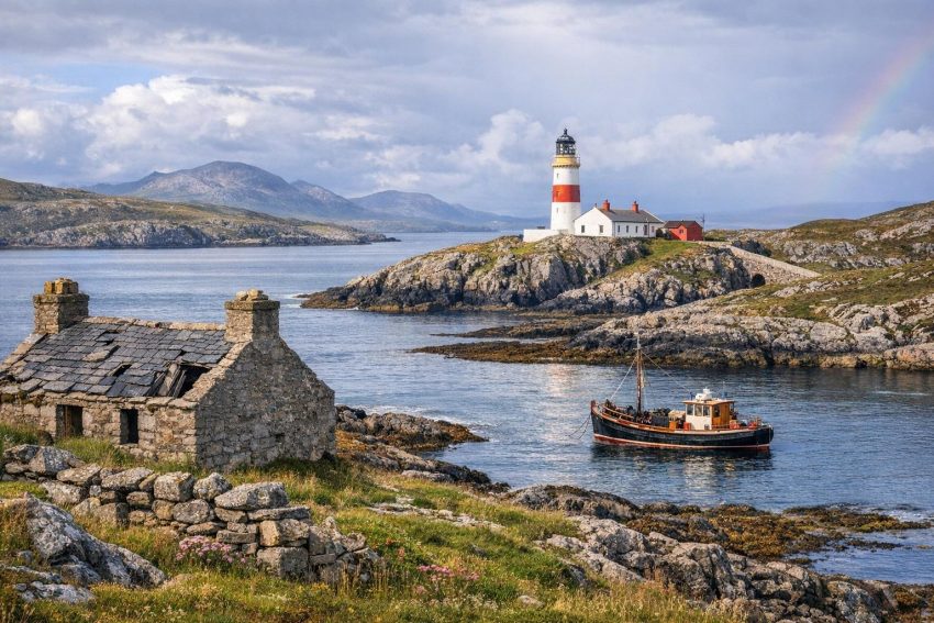
The Isle of Scalpay, known in Gaelic as Sgalpaigh, lies off the eastern coast of Harris in the Outer Hebrides. A narrow tidal channel separates it from Harris, while the Minch opens to the east. This position gave Scalpay ready access to fishing grounds and coastal sailing routes, though it also exposed residents to difficult tides, winter storms and long periods of poor travelling weather.
Scalpay covers about 6.5 square kilometres, or roughly 2.5 square miles. It is sometimes confused with the larger Scalpay near Skye, which accounts for occasional errors in descriptions of its area. The Harris island is compact, rocky and cut by sheltered inlets. Peat-covered ground, low hills, freshwater lochs and irregular shorelines dominate its physical character. Much of the population has lived around the northern and western shores, close to the safest landing places and the short crossing to Harris.
Although the island is small, its past reflects broad changes across the Hebrides. Gaelic society, Norse rule, clan authority, estate management, crofting, fishing, religious life and maritime trade all left marks on Scalpay. The opening of the road bridge in 1997 changed daily travel, but the sea governed movement for nearly all of the island’s recorded history.
Scalpay’s geography and maritime position
Scalpay’s location helps explain much of its history. It stands near the eastern approach to the Sound of Harris, one of the passages between the northern and southern parts of the Outer Hebrides. Vessels travelling between Lewis, Harris, North Uist, Skye and the Scottish mainland could pass close to the island. Local residents therefore lived beside both working fishing grounds and established sailing routes.
The island’s shoreline contains small bays that could shelter boats from certain wind directions. No anchorage was safe in every condition, however. A harbour that offered protection from a westerly wind might become hazardous when the weather shifted. Knowledge of reefs, currents and landing places passed between generations and formed a practical part of local education. Children growing up in fishing households learned to read tides and clouds long before anyone handed them a certificate for it.
Scalpay has little high-quality arable soil. Thin earth, exposed rock and waterlogged peat restricted the amount of grain and potatoes that families could grow. Crofting households responded by using several sources of food and income at once. Cattle, sheep, potatoes, oats and hay supported domestic life, while fishing supplied food and cash. Peat provided fuel, and shore resources added shellfish, seaweed, driftwood and bird eggs where customary rights allowed their collection.
Freshwater lochs also affected settlement. Houses needed reasonable access to water, grazing and cultivable ground, but they also had to remain close to landing places. As a result, buildings tended to gather in townships rather than spread evenly across the island. Older ruined houses, boundary walls and cultivation ridges still show where families once worked land that now appears empty.
The origin of the name Scalpay
The name Scalpay comes from the period of Norse influence in the Hebrides. Historical forms are commonly linked with Old Norse place-name roots, though scholars have proposed more than one translation. Interpretations include “scallop island” and names associated with shells or ships. Certainty is difficult because medieval spellings vary and spoken names changed as they passed between Norse and Gaelic speakers.
The modern Gaelic form, Sgalpaigh, retains the older name within Gaelic pronunciation. This mixture is common across the Hebrides. Norse-derived names often sit beside Gaelic names for hills, lochs, grazing areas and settlements. Place names can preserve details about former land use, natural features or personal ownership, though later spellings may obscure their first meaning.
Care is also needed because Scotland has more than one island called Scalpay. The Isle of Scalpay near Harris belongs to the Outer Hebrides, while another Scalpay lies off Skye in the Inner Hebrides. Historical documents do not always make the distinction plain, especially where an estate account or shipping record assumes local knowledge.
Prehistoric settlement and early communities
People occupied the Outer Hebrides thousands of years before written accounts began. Archaeological work across Lewis, Harris and the Uists has found houses, burial sites, field systems and ritual monuments from the Neolithic and Bronze Age. Scalpay has produced a smaller body of recorded archaeology, partly because of its size and partly because fewer formal surveys and excavations have taken place there.
The absence of a large excavated monument does not mean that early inhabitants ignored the island. Its sheltered water, freshwater supplies and marine food would have made seasonal or permanent occupation practical. Low stone structures, old banks and buried deposits may survive beneath later crofts or peat. Some remains are hard to date without excavation because islanders reused stone over long periods.
Early settlement probably depended on mixed farming. Households kept livestock, planted hardy crops and used the shore for food and raw materials. Boats linked nearby islands and allowed families to exchange goods, maintain kinship ties and travel to meeting places. The sea connected communities more often than it separated them.
Christianity reached the western islands during the early medieval centuries. Missionaries, monastic communities and local rulers supported chapels and burial grounds at coastal sites. Traditions associate various Hebridean locations with early saints, although oral accounts recorded centuries later cannot always be checked against contemporary evidence. On Scalpay, old religious associations belong to this wider pattern of coastal worship and burial rather than to a fully documented monastery.
Norse rule in the Hebrides
Scandinavian raiders began appearing around Britain and Ireland during the late eighth century. Raiding later gave way to settlement and political control. By the ninth and tenth centuries, Norse rulers had established authority across much of the Hebrides. The islands formed part of a maritime zone linked with western Scotland, Ireland, the Isle of Man, Orkney and Norway.
Norse control did not necessarily replace every earlier resident. Gaelic and Scandinavian communities lived alongside one another, intermarried and shared trading networks. The result was a mixed Norse-Gaelic culture that persisted for centuries. Personal names, boat terms and place names show this exchange more clearly than surviving political records do.
Scalpay’s position suited a society organised around ships. A boat offered transport, access to fish, military power and contact with regional markets. Land routes across the Highlands were often slow, whereas a capable crew could travel between islands with relative speed when weather permitted. Control of harbours and narrow passages therefore carried economic as well as military value.
The Norwegian crown retained formal claims over the Hebrides until the thirteenth century. Conflict between Norway and Scotland culminated in the campaign of 1263 and the Battle of Largs. The Treaty of Perth in 1266 transferred the Hebrides and the Isle of Man to the Scottish crown. Local authority did not change overnight. Regional families continued to govern through kinship, military strength and control of estates.
Scalpay and the Lordship of the Isles
During the later medieval period, the Lordship of the Isles became the leading power across much of the western Highlands and Hebrides. The Lords of the Isles drew authority from both Gaelic and Norse traditions. Their power rested on land, armed followers, kinship obligations and fleets of galleys capable of moving men between coastal strongholds.
Scalpay lay within reach of routes connecting Harris with Skye, North Uist and mainland ports. It did not become a grand political centre, but small islands could still support boats, livestock and tenants. They also provided staging points for travel through the Sound of Harris and the Minch.
The Scottish crown forfeited the Lordship in 1493. Crown authority then expanded unevenly across the region. Clan chiefs and local landlords retained considerable control, and disputes over land could continue for generations. Harris became associated chiefly with the MacLeods of Dunvegan and Harris, whose estate interests included Scalpay.
Medieval and early modern tenure rarely resembled modern private ownership. Chiefs granted areas to relatives or leading tenants, often called tacksmen. These men collected rents, organised military service and managed people below them in the social order. Ordinary tenants worked holdings according to local custom and paid rent through produce, labour, money or a combination of all three.
Clan authority and estate management
After the weakening of the Lordship, the Scottish government pressed Highland chiefs to accept central law, written titles and new forms of estate administration. Chiefs who had once acted as regional rulers increasingly became landlords. Rent collection and commercial income gained greater weight, especially from the seventeenth century onward.
For Scalpay residents, this shift affected grazing rights, rents and the security of occupation. Families might have lived in a township for generations without holding a permanent written lease. Their position depended on custom, the estate factor and the financial plans of the proprietor. A poor harvest or missed rent could place a household at risk.
Estate records can reveal names, rents, livestock numbers and arrears, but they rarely describe ordinary life in much detail. They tend to record people when money was owed, land was reassigned or a dispute arose. Gaelic oral history and family memory help fill some gaps, although such accounts also change through repeated telling.
The eighteenth century brought closer government supervision after the Jacobite risings. Roads, taxation, legal administration and commercial estate policies expanded across the Highlands. Scalpay remained dependent on boats for contact with officials and markets, yet decisions made in Edinburgh, Inverness or an estate office could still alter work and housing on the island.
Crofting and the township system
By the eighteenth and nineteenth centuries, most Scalpay households lived within a crofting economy. A croft usually consisted of a house site, patches of cultivable ground and rights in shared grazing. It was not designed to support a family through farming alone. Fishing, seasonal labour and the collection of shore resources made the holding workable.
Township residents managed grazing through agreed customs. Cattle and sheep used common land, while crops required protection behind walls, banks or fences. Families divided work according to season. Spring brought planting and repair work, summer required fishing and peat cutting, and autumn centred on harvest and livestock. Winter placed greater emphasis on net mending, spinning, boat repair and indoor tasks.
Arable land could be arranged in strips so that households received access to soils of differing quality. Redistribution sometimes occurred as families changed in size. This arrangement spread risk, but it could produce scattered plots that demanded extra labour. The better ground near houses often carried potatoes, oats or barley, while hay grew where drainage allowed.
Livestock acted as a store of value as well as a source of food. Cattle could be sold to pay rent, and sheep supplied wool and meat. Milk was used domestically, often in forms that kept longer than fresh milk. Ponies carried peat, seaweed and crops across ground unsuitable for wheeled vehicles.
Crofting depended on cooperation, though cooperation did not remove disagreement. Neighbours argued over wandering animals, peat boundaries and grazing just as rural communities did elsewhere. Even so, shared labour remained necessary for launching boats, roofing houses, harvesting crops and responding to accidents.
Traditional housing
Earlier houses on Scalpay were built from stone, turf and timber or driftwood. Thick double walls resisted wind and held insulating material. Rounded roof lines reduced exposure, while thatch was secured with ropes and weighted stones. Peat fires provided heat and cooked food.
Many Hebridean blackhouses placed animals and residents within connected parts of the same building. Livestock generated warmth during winter, but smoke, damp and poor ventilation affected health. The term blackhouse became common after newer “white houses” appeared with chimneys, mortared walls and separate byres.
Building styles changed gradually. Imported timber, corrugated iron, slate and cement became easier to obtain as transport improved. Some older houses became barns or stores rather than being abandoned at once. Ruined wall footings can therefore represent several phases of use.
Kelp production and coastal labour
Kelp burning brought cash income to many Hebridean estates during the late eighteenth century. Workers cut seaweed, carried it above the high-water mark, dried it and burned it in stone-lined pits or kilns. The ash contained chemicals used by glass, soap and textile manufacturers.
The work was dirty, smoky and dependent on weather. Seaweed had to dry well before burning, and rain could spoil days of labour. Estate owners benefited from high wartime prices and encouraged tenants to take part. Payment gave households access to cash in a society where rents and imported goods increasingly required money.
After the Napoleonic Wars, cheaper foreign alkalis and industrial chemical production reduced demand for Hebridean kelp. Prices fell rapidly. Families who had come to rely on the trade lost income, while many landlords retained rent expectations formed during the profitable years. The collapse added pressure to communities already dealing with population growth and small holdings.
Nineteenth-century hardship and land pressure
The nineteenth century brought sharp social and economic change throughout the Highlands and Islands. Landlords reorganised estates to raise income, sometimes creating large sheep farms or sporting properties. Tenants in several districts were moved from better ground to smaller coastal holdings. This process formed part of the Highland Clearances.
Scalpay did not experience every clearance policy in the same manner as mainland glens or larger islands. Even so, residents lived within the same estate system. Rent changes, crowded crofts and insecure tenure affected household decisions. Some families moved between Hebridean settlements, while others left Scotland.
Population growth increased strain on cultivable land. Subdivision gave married children somewhere to live, but each division reduced the amount available to a household. Fishing could offset that loss during good seasons. Bad weather, poor catches or low prices quickly exposed the weakness of the arrangement.
Emigration offered one response. Hebrideans moved to Canada, the United States, Australia and other parts of the British Empire. Some received estate assistance, some followed relatives and others paid their own fares after years of saving. Emigration could remove an entire household or begin a chain in which siblings and cousins left over several decades.
The potato famine
Potatoes became central to Hebridean food production because they produced a useful crop from relatively poor soil. Dependence on one crop carried a clear risk. Potato blight reached the Highlands and Islands during the 1840s, causing repeated failures and severe food shortages.
Relief committees supplied meal, seed and employment, often requiring labour on roads or drainage works. Charitable support prevented some deaths, but it did not repair the basic shortage of land and income. Fishing earnings varied, and imported grain cost money that many crofting households did not have.
The famine encouraged further migration and altered relations between tenants, landlords and government. It also contributed to later arguments over crofting rights. By the late nineteenth century, protests across the Highlands and Islands demanded fair rents, secure tenure and access to land.
Crofting reform
The Crofters Holdings (Scotland) Act 1886 granted legal protections to many crofters. It introduced security of tenure, fair-rent procedures and compensation for improvements. The law did not settle every grievance, and access to additional land remained contested, but it changed the balance between landlords and tenants.
On islands such as Scalpay, legal security allowed families to invest in houses, drainage and fences with less fear that their work would be lost through eviction. Crofting remained economically difficult, yet it gained a regulated status that continues to influence land use in the Outer Hebrides.
Fishing as Scalpay’s principal industry
Fishing stood at the centre of Scalpay’s economy for generations. Small open boats worked close to the island, while larger vessels travelled farther into the Minch. Crews caught white fish, herring and mackerel, along with lobster and crab. The preferred catch varied by season, market prices and available gear.
Early boats relied on oars and sail. Fishing required close attention to wind and tide because crews could not rely on engines to return against deteriorating weather. Boats were expensive assets, and several men might share ownership. Nets and lines also demanded regular repair.
Herring fisheries created periods of intense activity around the Scottish coast during the nineteenth and early twentieth centuries. Shoals moved seasonally, drawing boats, merchants, coopers and fish workers from one port to another. Scalpay fishermen could join this mobile industry while their families maintained crofts at home.
Women played a large part in the fishing economy. They prepared bait, repaired nets, processed catches, managed households and carried out croft work while men were away. In herring districts, women also travelled as gutters and packers. Official records often describe the occupation of a household through the male head, which can conceal much of this labour.
The arrival of motorised boats changed fishing patterns. Engines reduced dependence on favourable winds and allowed crews to reach grounds more quickly. They also brought fuel costs, mechanical maintenance and pressure to land enough fish to cover higher operating expenses. Harbour improvements and road transport later connected catches with buyers beyond the island.
| Period | Common maritime activity | Effect on island households |
|---|---|---|
| Before the nineteenth century | Inshore line fishing, shellfish collection and local transport | Food supply, barter and small cash sales |
| Nineteenth century | Herring, white fish and seasonal coastal fisheries | More contact with merchants and distant ports |
| Early to mid-twentieth century | Motorised boats and organised fish markets | Higher output alongside greater operating costs |
| Later twentieth century onward | Commercial fishing, shellfish and regulated quotas | Fewer crews, larger capital needs and changing markets |
Fishing declined as a full-time occupation for many residents during the later twentieth century. Stock changes, regulation, fuel prices and market concentration all played a part. Shellfish remained valuable, but entry costs and licensing could restrict newcomers. Crofting and fishing continued as part-time work alongside wages from construction, transport, public services and businesses on Harris.
Eilean Glas Lighthouse
Eilean Glas Lighthouse stands on Scalpay’s eastern side, facing the Minch. The site is among the oldest lighthouse stations in Scotland and was the first established in the Outer Hebrides. Its original light began operating in 1789, only a few years after the Commissioners of Northern Lights were created.
The commissioners selected the site because ships using the Minch needed a dependable mark near the approaches to Harris. Reefs, poor visibility and strong currents made the passage dangerous, especially before accurate charts and powered vessels became common. A shore light gave mariners a fixed point from which to judge position.
Engineer Thomas Smith designed the first lighthouse. The present tower dates from 1824 and is associated with Robert Stevenson, a member of the family responsible for many Scottish lights. Later work altered the accommodation and technical apparatus. The familiar painted tower became a prominent day mark as well as a night aid.
Lighthouse keeping required routine and discipline. Keepers cleaned lenses, maintained lamps, recorded weather and watched machinery. Before automation, fuel and stores arrived by sea or over difficult island tracks. Families living at the station dealt with isolation, school arrangements and harsh weather, even though Scalpay’s settled townships were not far away in straight-line distance.
The station was automated in 1978. Remote operation removed the need for resident keepers, reflecting changes across the Northern Lighthouse Board network. The tower still operates as a navigational aid, while the former domestic and service buildings record the period of permanent staffing.
Eilean Glas also shows that Scalpay’s past cannot be reduced to crofting alone. The island served national and commercial shipping through an institution funded and administered far beyond Harris. Local labour, visiting engineers, lighthouse families and supply vessels connected the station with ports across Scotland.
Religion and church life
Religion strongly influenced social life in Scalpay, particularly after Presbyterian churches became firmly established in Harris. Worship, Sabbath observance, prayer meetings and communion seasons ordered the calendar. Church membership also provided networks of care during illness, bereavement and poverty.
Religious divisions within Scottish Presbyterianism reached the island. The Church of Scotland, Free Church and later bodies developed separate congregations in many Highland parishes after disputes over patronage, doctrine and church government. A small population could therefore support more than one religious affiliation, sometimes within the same extended family.
The Sabbath traditionally restricted ordinary work, travel and recreation. Fishing crews planned around Sunday where possible, though danger at sea could override normal practice. Strict observance remained more visible in Lewis and Harris than in many other parts of Scotland well into the twentieth century.
Church services also sustained Gaelic. Preaching, psalm singing and religious discussion used the language long after English had gained ground in administration and secondary education. Unaccompanied Gaelic psalmody became one of the best-known features of Hebridean worship, with each singer following the line in a slightly different melodic form.
Gaelic language and oral history
Gaelic served as Scalpay’s main community language for much of its history. It carried local knowledge about fishing grounds, weather, kinship and croft boundaries. Personal nicknames helped distinguish residents who shared a small number of surnames and given names, a practical habit in close communities.
English expanded through schools, official paperwork, military service, broadcasting and employment away from the island. Earlier education policies often treated Gaelic as an obstacle rather than an academic asset. Children could speak Gaelic at home yet conduct most formal schoolwork in English.
Later policy gave Gaelic a stronger place in education and public services. Even so, transmission depends mainly on regular use between generations. A language may appear on signs and forms while becoming less common in kitchens, boats and workplaces. Scalpay retains a strong Gaelic association, but it shares the demographic pressures seen across the Outer Hebrides.
Oral history preserves accounts that estate papers and census returns omit. Stories of storms, boat losses, marriages, migrations and unusual catches attach people to named places. Such evidence needs careful comparison with written records, but it offers details about motive and character that administrative documents rarely supply.
Schools, shops and domestic life
The school served as more than a classroom. It brought children from scattered homes into one institution and linked the island with national education policy. Teachers often arrived from elsewhere, though some were native Gaelic speakers. Attendance could conflict with seasonal work when children were needed for harvesting, peat cutting or household tasks.
Small shops supplied flour, tea, sugar, tools, paraffin and later packaged goods. Before regular road access, merchants depended on boats and weather. A delayed delivery was not a minor inconvenience if flour or fuel stocks were already low. Households therefore stored food where possible and relied on neighbours during shortages.
The post office connected Scalpay with relatives who had moved to Glasgow, Canada or other destinations. Letters carried money, news and notice of work. Postal services later handled pensions and government payments, making the post office both a communications centre and a basic financial counter.
Domestic technology altered work across the twentieth century. Electricity, piped water, washing machines, telephones and improved heating reduced hours of physical labour. Their arrival did not happen all at once. Infrastructure costs were high, and exposed weather made construction and maintenance demanding.
Medical care presented another concern. Minor illnesses could be managed locally, but serious cases required travel to Harris or farther afield. Before dependable motor transport and the bridge, weather might delay a doctor, nurse or patient. Communities developed strong informal care practices because professional help was not always close at hand.
War service and twentieth-century change
Men from Scalpay served in the armed forces and merchant shipping during the two world wars. Maritime experience made islanders valuable to the Royal Navy and Merchant Navy, though it also placed them in dangerous duties. War memorials and family histories record losses that affected a small population heavily.
Service exposed young residents to cities, industrial employment and other countries. Some returned after demobilisation, while others settled near new jobs. The same pattern appeared during later decades as education and wage employment drew people away from crofting communities.
After 1945, housing standards improved and public services expanded. Roads, electricity and telecommunications reduced physical isolation. Mechanised equipment changed croft work, and motor vessels altered fishing. These gains coincided with population decline because fewer workers were needed in traditional industries and younger residents had broader employment options elsewhere.
Census totals vary by date and definition, but the broad direction is clear: Scalpay supported a larger population during parts of the nineteenth and early twentieth centuries than it does now. Empty houses and former cultivation plots reflect migration as much as agricultural change. Some homes became holiday properties, while descendants continued to return for family events and seasonal visits.
Travel before the Scalpay Bridge
For most of recorded time, every person, animal and bulky item entering or leaving Scalpay travelled by boat. The crossing to Harris is short, yet short sea passages can be troublesome. Tidal streams, strong winds and darkness affected even routine trips.
Rowing boats and sailing craft carried residents before powered ferries became available. Livestock transport demanded calm handling and good weather. Building stone could be sourced locally, but timber, roofing materials, machinery and fuel generally came from outside. Each cargo required loading and unloading at a usable shore point.
A regular ferry made travel more dependable and allowed vehicles to cross, though it still worked within timetable and weather restrictions. Missed sailings affected school attendance, medical appointments, freight and commuting. Residents often planned around the last ferry rather than around the preferred time of travel.
The opening of the Scalpay Bridge
The Scalpay Bridge opened in 1997 and gave the island a permanent road connection to Harris. The single-lane structure crosses the narrow channel at the western side of the island. It ended routine dependence on the ferry and allowed vehicles to travel directly between Scalpay and Tarbert.
The bridge changed daily habits quickly. Residents could commute to work, attend appointments and shop without checking a sailing schedule. Emergency vehicles gained direct access, and builders could bring materials across by road. School and public-service transport also became easier to arrange.
A fixed link did not remove every transport issue. Scalpay still depends on the Harris road network and ferry or air links from the Outer Hebrides to mainland Scotland. Bad weather can still disrupt freight and regional travel. The bridge nevertheless removed one vulnerable stage from almost every trip.
Local commerce faced mixed effects. Businesses gained easier deliveries and access to customers from Harris, but residents could also shop outside the island with less effort. This pattern is common after transport connections improve: the same road carries money in both directions.
Community ownership and land management
Land reform gained renewed attention in the Highlands and Islands during the late twentieth and early twenty-first centuries. Community bodies began purchasing estates so that residents could influence housing, business premises, renewable-energy projects and environmental management.
Scalpay joined this movement through arrangements linking the island with community ownership in North Harris. In 2012, residents voted in favour of joining the North Harris Trust after the owner offered the land for community benefit. The transfer marked a major change from centuries of control by private proprietors and estate managers.
Community ownership does not produce instant prosperity. Land still requires maintenance, legal administration and income. Housing shortages, an ageing population and the cost of construction remain persistent concerns. Local control does, however, give residents a formal voice in decisions about sites, leases and development priorities.
Affordable housing matters because empty property does not always translate into available homes. Some buildings need costly repair, while holiday use and second-home demand can raise prices. New construction must also account for peat, drainage, road access and exposure to Atlantic weather.
Work and life on modern Scalpay
Modern employment combines older occupations with wage work. Crofting and fishing continue, often on a part-time basis. Residents also work in construction, transport, education, healthcare, retail, tourism and public administration. The bridge makes commuting to Tarbert and other parts of Harris practical.
Visitors come for coastal walking, birdlife, fishing heritage and Eilean Glas Lighthouse. Tourism supports accommodation and local services, though demand is seasonal. Winter business can be thin, while summer traffic places extra pressure on narrow roads, parking areas and waste services.
Access rights allow responsible recreation across much of Scotland, but visitors still need to respect crofts, livestock and homes. Gates should be left as found, dogs require control near sheep, and vehicles should not block passing places. Old walls and ruined buildings may look solid yet collapse when climbed.
Peatland and coastal ground recover slowly after damage. Repeated foot traffic can widen wet paths and expose soil. Archaeological remains also deserve care because an undisturbed bank may contain evidence that has survived for centuries. Simple restraint usually does the job; no grand management theory is required.
Reading Scalpay’s history in the island itself
Much of Scalpay’s past remains visible outside archives. Croft boundaries show how land was divided. Ruined houses record former population centres, while improved dwellings illustrate changing building standards. Peat cuttings reveal generations of fuel gathering, and landing places show where boats connected settlements before modern piers and roads.
Eilean Glas records the growth of state-supported navigation. Churches and burial grounds reflect religious practice and family continuity. Gaelic place names preserve descriptions and associations that may be older than surviving buildings. The bridge represents the latest major change in movement between Scalpay and Harris.
Written evidence includes censuses, valuation rolls, parish records, estate papers, maps and lighthouse reports. Each source has limits. Census forms provide household details at ten-year intervals but say little about seasonal work. Estate papers focus on rent and property. Maps may omit temporary buildings, local names or informal tracks.
Oral accounts add personal experience, though dates and sequences may shift over time. The best historical reading compares memories with documents and physical remains. A family story about an abandoned house becomes more useful when checked against a census, croft record and map.
Why Scalpay matters in Hebridean history
Scalpay offers a concentrated record of life in the eastern Outer Hebrides. Its residents combined crofting with fishing, lived under clan and estate authority, endured famine and migration, and maintained Gaelic culture through major political and economic change.
The island also held a strategic maritime position. Norse sailors, fishing crews, merchants and lighthouse authorities all used the waters around it. Eilean Glas served shipping far beyond the local community, while generations of Scalpay mariners applied their knowledge across Scottish and overseas waters.
The 1997 bridge altered a pattern that had lasted for centuries, but it did not erase the island’s maritime character. Boats, fishing grounds and coastal weather remain part of daily experience. Community ownership has added another chapter by giving residents a direct part in managing land once controlled through private estates.
Scalpay’s history survives through more than dates and ownership records. It remains present in ruined crofts, working boats, Gaelic speech, church traditions, family names and the lighthouse above the Minch. Together, those records show how a small island community adapted without losing its connection to place.